Tập tin:Mare Tranquillitatis map.jpg
Kích thước hình xem trước: 343×344 điểm ảnh. Độ phân giải khác: 239×240 điểm ảnh.
Tập tin gốc (343×344 điểm ảnh, kích thước tập tin: 69 kB, kiểu MIME: image/jpeg)
| Tập tin này từ Wikimedia Commons. Trang miêu tả nó ở đấy được sao chép dưới đây. Commons là kho lưu trữ tập tin phương tiện có giấy phép tự do. Bạn có thể tham gia. |
Miêu tả
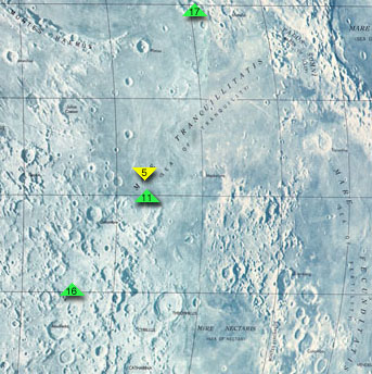
Map of Mare Tranquillitatis, cropped from http://www.jpl.nasa.gov/history/60s/Surveyor7_1968.htm[dead link].
The colored arrows indicate the landing sites of Apollo 11, the first manned moon mission, Apollo 17, Apollo 16, and Surveyor 5. To the southeast is Mare Fecunditatis, to the northeast is Mare Crisium, and to the south is Mare Nectaris.
Secondary source: http://en.wikipedia.org/wiki/Image:Mare_Tranquillitatis_map.jpg
Giấy phép
| This file is in the public domain in the United States because it was solely created by NASA. NASA copyright policy states that "NASA material is not protected by copyright unless noted". (See Template:PD-USGov, NASA copyright policy page or JPL Image Use Policy.) | ||
 | Warnings:
|
Lịch sử tập tin
Nhấn vào ngày/giờ để xem nội dung tập tin tại thời điểm đó.
| Ngày/giờ | Hình xem trước | Kích cỡ | Thành viên | Miêu tả | |
|---|---|---|---|---|---|
| hiện tại | 23:00, ngày 25 tháng 8 năm 2005 | | 343×344 (69 kB) | Mattes | new |
Trang sử dụng tập tin
Có 1 trang tại Wikipedia tiếng Việt có liên kết đến tập tin (không hiển thị trang ở các dự án khác):
Sử dụng tập tin toàn cục
Những wiki sau đang sử dụng tập tin này:
- Trang sử dụng tại af.wikipedia.org
- Trang sử dụng tại bg.wikipedia.org
- Trang sử dụng tại cs.wikipedia.org
- Trang sử dụng tại da.wikipedia.org
- Trang sử dụng tại de.wikipedia.org
- Trang sử dụng tại en.wikipedia.org
- Trang sử dụng tại es.wikipedia.org
- Trang sử dụng tại fa.wikipedia.org
- Trang sử dụng tại fi.wikipedia.org
- Trang sử dụng tại fr.wikipedia.org
- Trang sử dụng tại he.wikipedia.org
- Trang sử dụng tại it.wikipedia.org
- Trang sử dụng tại ka.wikipedia.org
- Trang sử dụng tại ko.wikipedia.org
- Trang sử dụng tại lb.wikipedia.org
- Trang sử dụng tại nl.wikipedia.org
- Trang sử dụng tại pl.wikipedia.org
- Trang sử dụng tại pt.wikipedia.org
- Trang sử dụng tại ro.wikipedia.org
- Trang sử dụng tại ru.wikipedia.org
- Trang sử dụng tại simple.wikipedia.org
- Trang sử dụng tại sv.wikipedia.org
- Trang sử dụng tại zh.wikipedia.org