
Tập tin:Joppen map-India in 1525 published 1907 by Longmans.jpg
Kích thước hình xem trước: 408×600 điểm ảnh. Độ phân giải khác: 163×240 điểm ảnh | 326×480 điểm ảnh | 522×768 điểm ảnh | 696×1.024 điểm ảnh | 1.893×2.783 điểm ảnh.
Tập tin gốc (1.893×2.783 điểm ảnh, kích thước tập tin: 1,57 MB, kiểu MIME: image/jpeg)
| Tập tin này từ Wikimedia Commons. Trang miêu tả nó ở đấy được sao chép dưới đây. Commons là kho lưu trữ tập tin phương tiện có giấy phép tự do. Bạn có thể tham gia. |
Miêu tả
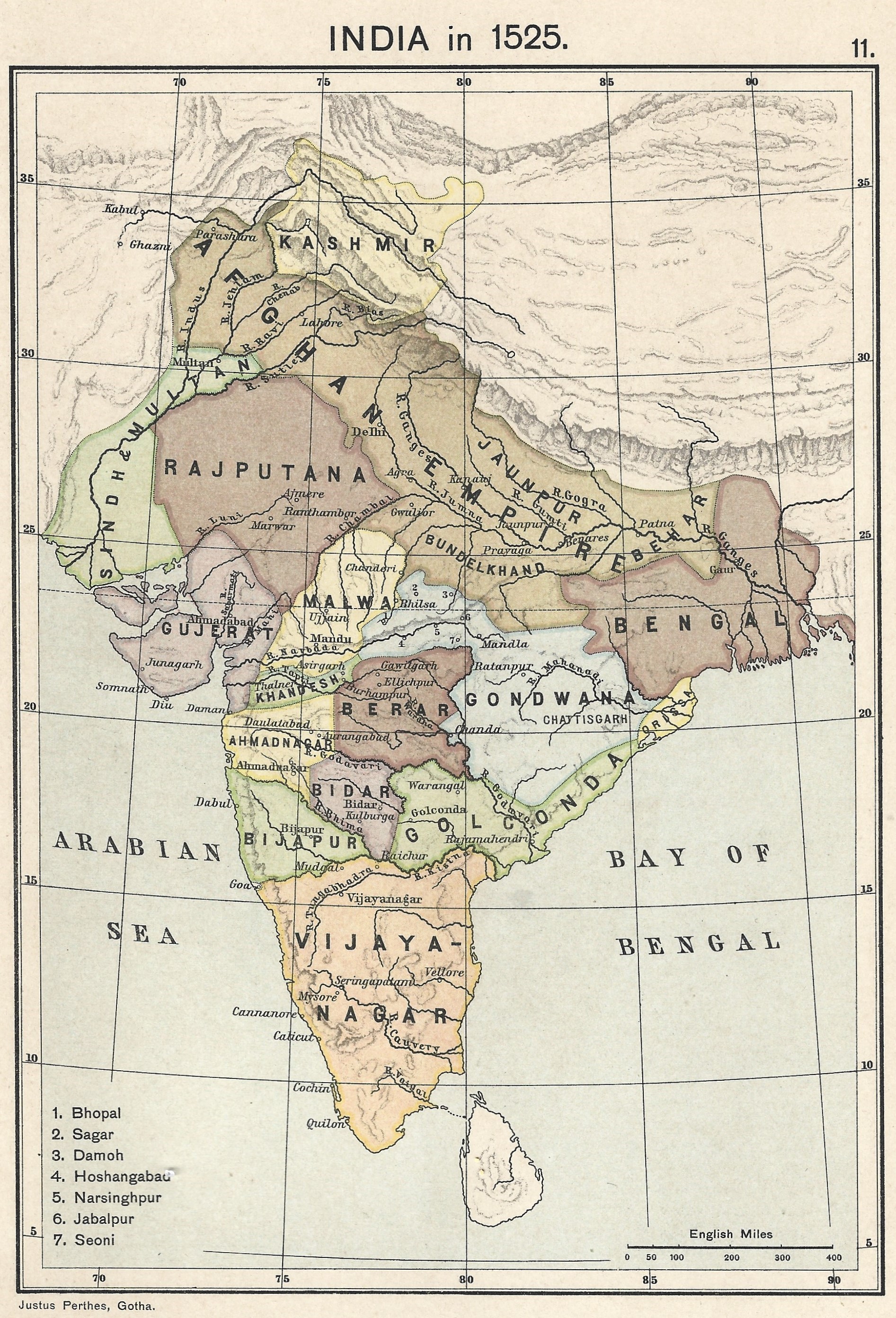
| Miêu tả | English: A map of India in 1525 on the eve of the Mughal conquest of Upper India, scanned from the personal copy of Historical Atlas of India by Charles Joppen SJ, Longmans, Green and Co, 1907 by Fowler&fowler (thảo luận) 13:52, 10 July 2023 (UTC) |
| Ngày | |
| Nguồn gốc | Map of India 1525 showing India just before the Mughal conquest of Upper India from: Joppen, Charles [SJ.] (1907) A Historical Atlas of India for the use of High-Schools, Colleges, and Private Students, London, New York, Bombay, and Calcutta: Longman Green and Co. Pp. 16, 26 maps. |
| Tác giả | Justus Perthes, Gotha./Charles Joppen Joppen, Charles [SJ.] (1907) A Historical Atlas of India for the use of High-Schools, Colleges, and Private Students, London, New York, Bombay, and Calcutta: Longman Green and Co. Pp. 16, 26 maps |
Giấy phép
Tác phẩm này thuộc về phạm vi công cộng ở Hoa Kỳ vì nó được phát hành trước ngày 1 tháng 1 năm 1931. Tác phẩm thuộc phạm vi công cộng phải hết hạn bản quyền ở cả Hoa Kỳ lẫn quốc gia gốc của tác phẩm thì mới có thể lưu trữ tại Commons. Nếu tác phẩm không phải của Hoa Kỳ, tập tin phải có một thẻ bản quyền nữa để ghi rõ tình trạng bản quyền của quốc gia gốc. |
Lịch sử tập tin
Nhấn vào ngày/giờ để xem nội dung tập tin tại thời điểm đó.
| Ngày/giờ | Hình xem trước | Kích cỡ | Thành viên | Miêu tả | |
|---|---|---|---|---|---|
| hiện tại | 13:52, ngày 10 tháng 7 năm 2023 | | 1.893×2.783 (1,57 MB) | Fowler&fowler | Uploaded a work by Justus Perthes, Gotha./Charles Joppen {{Citation|last=Joppen|first=Charles [SJ.]|year=1907|title=A Historical Atlas of India for the use of High-Schools, Colleges, and Private Students|publisher=London, New York, Bombay, and Calcutta: Longman Green and Co. Pp. 16, 26 maps}} from Map of India 1700 showing the Mughal Empire and European trading posts/factory towns from: {{Citation|last=Joppen|first=Charles [SJ.]|year=1907|title=A Historical Atlas of India for the use of High-... |
Trang sử dụng tập tin
Có 1 trang tại Wikipedia tiếng Việt có liên kết đến tập tin (không hiển thị trang ở các dự án khác):
Sử dụng tập tin toàn cục
Những wiki sau đang sử dụng tập tin này:
- Trang sử dụng tại arz.wikipedia.org
- Trang sử dụng tại bs.wikipedia.org
- Trang sử dụng tại en.wikipedia.org
- Trang sử dụng tại es.wikipedia.org
- Trang sử dụng tại fa.wikipedia.org
- Trang sử dụng tại ko.wikipedia.org
- Trang sử dụng tại new.wikipedia.org