Tập tin:Strait of Hormuz and Musandam Peninsula (MODIS 2018-12-10).jpg
Kích thước hình xem trước: 748×600 điểm ảnh. Độ phân giải khác: 299×240 điểm ảnh | 599×480 điểm ảnh | 958×768 điểm ảnh | 1.277×1.024 điểm ảnh | 2.320×1.860 điểm ảnh.
Tập tin gốc (2.320×1.860 điểm ảnh, kích thước tập tin: 453 kB, kiểu MIME: image/jpeg)
| Tập tin này từ Wikimedia Commons. Trang miêu tả nó ở đấy được sao chép dưới đây. Commons là kho lưu trữ tập tin phương tiện có giấy phép tự do. Bạn có thể tham gia. |
.jpg?uselang=vi)
Miêu tả
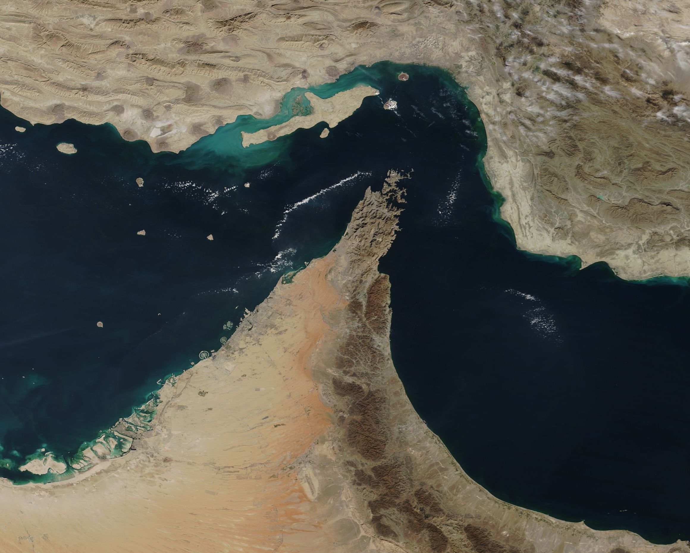
| Miêu tả | English: The rugged, barren mountains of the Musandam Peninsula jut into the Strait of Hormuz, the narrow throughway between Iran (north) and Oman and the United Arab Emirates (south) where the waters from the Gulf of Oman enter the Persian Gulf. Khasab, Oman, the main city sitting on the tip of the Musandam Peninsula, sits only 65 km (40 mi) from the Iranian city of Bandar Abbas. The rocky limestone mountains of the peninsula rise as high as 6,500 feet (2,000 meters) above sea level and create fjord-like inlets along the coast. Musandam is an exclave of Oman, separated from the rest of the country by the United Arab Emirates. Fishing, agriculture and ship building are the primary industries in this part of Oman.The Moderate Resolution Imaging Spectroradiometer (MODIS) on board NASA’s Terra satellite acquired a stunning true-color image of the Strait of Hormuz and the Musandam Peninsula on December 6, 2018. | ||
| Ngày | Taken on 6 tháng 12 năm 2018 | ||
| Nguồn gốc | Strait of Hormuz and Musandam Peninsula (direct link)
| ||
| Tác giả | MODIS Land Rapid Response Team, NASA GSFC |
| This media is a product of the Terra mission Credit and attribution belongs to the mission team, if not already specified in the "author" row |
Giấy phép
| This file is in the public domain in the United States because it was solely created by NASA. NASA copyright policy states that "NASA material is not protected by copyright unless noted". (See Template:PD-USGov, NASA copyright policy page or JPL Image Use Policy.) | ||
 | Warnings:
|
Lịch sử tập tin
Nhấn vào ngày/giờ để xem nội dung tập tin tại thời điểm đó.
| Ngày/giờ | Hình xem trước | Kích cỡ | Thành viên | Miêu tả | |
|---|---|---|---|---|---|
| hiện tại | 01:20, ngày 17 tháng 2 năm 2024 | | 2.320×1.860 (453 kB) | OptimusPrimeBot | #Spacemedia - Upload of http://modis.gsfc.nasa.gov/gallery/images/image12102018_250m.jpg via Commons:Spacemedia |
Trang sử dụng tập tin
Có 1 trang tại Wikipedia tiếng Việt có liên kết đến tập tin (không hiển thị trang ở các dự án khác):
Sử dụng tập tin toàn cục
Những wiki sau đang sử dụng tập tin này:
- Trang sử dụng tại als.wikipedia.org
- Trang sử dụng tại de.wikipedia.org
- Trang sử dụng tại dty.wikipedia.org
- Trang sử dụng tại en.wikipedia.org
- Trang sử dụng tại en.wiktionary.org
- Trang sử dụng tại eu.wikipedia.org
- Trang sử dụng tại iba.wikipedia.org
- Trang sử dụng tại id.wikipedia.org
- Trang sử dụng tại lo.wikipedia.org
- Trang sử dụng tại mk.wikipedia.org
- Trang sử dụng tại mt.wikipedia.org
- Trang sử dụng tại ps.wikipedia.org
- Trang sử dụng tại pt.wikinews.org
- Trang sử dụng tại sd.wikipedia.org
- Trang sử dụng tại zh-min-nan.wikipedia.org
.jpg)