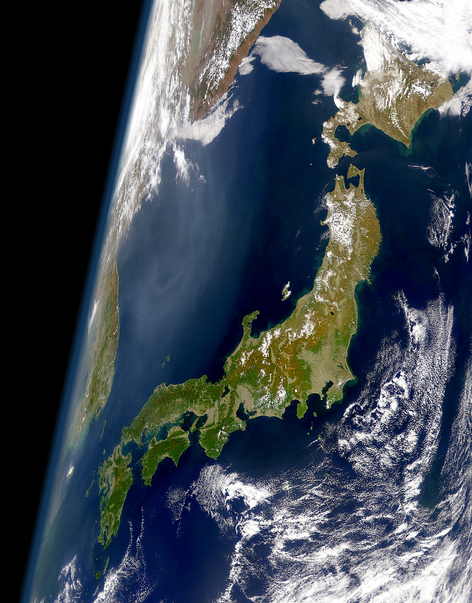
Tập tin:Satellite View of Japan 1999.jpg
Kích thước hình xem trước: 469×599 điểm ảnh. Độ phân giải khác: 188×240 điểm ảnh | 376×480 điểm ảnh | 601×768 điểm ảnh | 802×1.024 điểm ảnh | 1.638×2.092 điểm ảnh.
Tập tin gốc (1.638×2.092 điểm ảnh, kích thước tập tin: 1,04 MB, kiểu MIME: image/jpeg)
Tập tin này từ Wikimedia Commons. Trang miêu tả nó ở đấy được sao chép dưới đây. Commons là kho lưu trữ tập tin phương tiện có giấy phép tự do. Bạn có thể tham gia. |
Miêu tả
| Miêu tả | English: View of Japan taken from a satellite (1999) 日本語: 衛星から見た日本(1999年) |
| Ngày | |
| Nguồn gốc | Cropped version of the high resolution variation of image found at: https://visibleearth.nasa.gov/images/52957/clear-view-of-japan |
| Tác giả | SeaWiFS Project, NASA/Goddard Space Flight Center, and ORBIMAGE |
Giấy phép
| This image is from the Sea-viewing Wide Field-of-view Sensor (SeaWiFS) Project and more than 5 years old. Satellite data captured by the SeaWIFS sensor are released into the public domain 5 years after capture. Data less than five years old can be re-used only for educational or scientific purposes; any commercial use of such images must be coordinated with GeoEye. [1] |
| This work has been released into the public domain by its copyright holder, GeoEye. This applies worldwide. Tại một quốc gia mà luật pháp không cho phép điều này, thì: GeoEye cho phép tất cả mọi người được quyền sử dụng tác phẩm này với bất cứ mục đích nào, không kèm theo bất kỳ điều kiện nào, trừ phi luật pháp yêu cầu những điều kiện đó. |
Lịch sử tập tin
Nhấn vào ngày/giờ để xem nội dung tập tin tại thời điểm đó.
| Ngày/giờ | Hình xem trước | Kích cỡ | Thành viên | Miêu tả | |
|---|---|---|---|---|---|
| hiện tại | 01:11, ngày 26 tháng 1 năm 2008 | | 1.638×2.092 (1,04 MB) | Satelite of Love | {{Information |Description=View of Japan take from a satellite (1999) |Source=Cropped version of the high resolution variation of image found at: http://visibleearth.nasa.gov/cgi-bin/viewrecord?10466 |Date=Jan. 24, 2008 |Author= [[User:Satelite of Love|Sa |
Trang sử dụng tập tin
Có 5 trang tại Wikipedia tiếng Việt có liên kết đến tập tin (không hiển thị trang ở các dự án khác):
Sử dụng tập tin toàn cục
Những wiki sau đang sử dụng tập tin này:
- Trang sử dụng tại af.wikipedia.org
- Trang sử dụng tại am.wikipedia.org
- Trang sử dụng tại ar.wikipedia.org
- Trang sử dụng tại ast.wikipedia.org
- Trang sử dụng tại azb.wikipedia.org
- Trang sử dụng tại bat-smg.wikipedia.org
- Trang sử dụng tại be-tarask.wikipedia.org
- Trang sử dụng tại be.wikipedia.org
- Trang sử dụng tại bg.wikipedia.org
- Trang sử dụng tại bm.wikipedia.org
- Trang sử dụng tại bn.wikipedia.org
- Trang sử dụng tại bo.wikipedia.org
- Trang sử dụng tại br.wiktionary.org
- Trang sử dụng tại bs.wikipedia.org
- Trang sử dụng tại ca.wikipedia.org
- Trang sử dụng tại ca.wikinews.org
- Trang sử dụng tại cs.wikipedia.org
- Trang sử dụng tại da.wikipedia.org
- Trang sử dụng tại de.wikipedia.org
- Trang sử dụng tại el.wikipedia.org
- Trang sử dụng tại en.wikipedia.org
- Trang sử dụng tại en.wikibooks.org
- Trang sử dụng tại en.wikiquote.org
- Trang sử dụng tại eo.wikipedia.org
- Trang sử dụng tại es.wikipedia.org
- Trang sử dụng tại et.wikipedia.org
- Trang sử dụng tại fa.wikipedia.org
- Trang sử dụng tại fi.wikipedia.org
- Trang sử dụng tại fr.wikipedia.org
- Trang sử dụng tại gl.wikipedia.org
- Trang sử dụng tại hi.wikipedia.org
- Trang sử dụng tại hr.wikipedia.org
- Trang sử dụng tại hy.wikipedia.org
- Trang sử dụng tại id.wikipedia.org
Xem thêm các trang toàn cục sử dụng tập tin này.