Tập tin:Physical Map of Europe.jpg
Không có độ phân giải cao hơn.
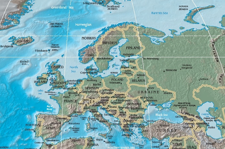
Physical_Map_of_Europe.jpg (719×476 điểm ảnh, kích thước tập tin: 185 kB, kiểu MIME: image/jpeg)
Tập tin này từ Wikimedia Commons. Trang miêu tả nó ở đấy được sao chép dưới đây. Commons là kho lưu trữ tập tin phương tiện có giấy phép tự do. Bạn có thể tham gia. |
- Extended map (enlarged labels): Image:Europe_terrain_CIA_map_extended.jpg.
Miêu tả
| Miêu tả | Terrain map of Europe, as cropping from the CIA's Physical Map of the World. |
| Ngày | Map dated April 2008 |
| Nguồn gốc | Cropped section from the CIA's Physical Map of the World, formerly available at: but moved to webpage (March 2009): Those webpage URLs require secure-post ("https"), for access, because those pages are encrypted. The larger image this one was cropped from may or may not still be available. |
| Tác giả | work of U.S. CIA |
| Phiên bản khác | Same map in expanded form (more labels):
|
Giấy phép
This image is in the public domain because it contains materials that originally came from the United States Central Intelligence Agency's World Factbook. |  |
Lịch sử tập tin
Nhấn vào ngày/giờ để xem nội dung tập tin tại thời điểm đó.
| Ngày/giờ | Hình xem trước | Kích cỡ | Thành viên | Miêu tả | |
|---|---|---|---|---|---|
| hiện tại | 11:56, ngày 19 tháng 10 năm 2005 | | 719×476 (185 kB) | Grillo | Physical map of Europe. Cropped from http://cia.gov/cia/publications/factbook/reference_maps/pdf/physical_world.pdf and converted to JPG. From en:Image:Physical Map of Europe.jpg {{PD-USGov-CIA-WF}} |
Trang sử dụng tập tin
Có 3 trang tại Wikipedia tiếng Việt có liên kết đến tập tin (không hiển thị trang ở các dự án khác):
Sử dụng tập tin toàn cục
Những wiki sau đang sử dụng tập tin này:
- Trang sử dụng tại as.wikipedia.org
- Trang sử dụng tại bat-smg.wikipedia.org
- Trang sử dụng tại bg.wiktionary.org
- Trang sử dụng tại cy.wikipedia.org
- Trang sử dụng tại da.wikipedia.org
- Sveriges geografi
- Norges geografi
- Danmarks geografi
- Frankrigs geografi
- Irlands geografi
- Liechtensteins geografi
- Tysklands geografi
- Østrigs geografi
- Europas geografi
- Slovakiets geografi
- Monacos geografi
- Tjekkiets geografi
- Sloveniens geografi
- Storbritanniens geografi
- Tyrkiets geografi
- Schweiz' geografi
- Skabelon:Europas geografi
- Hollands geografi
- Ukraines geografi
- Grækenlands geografi
- Trang sử dụng tại de.wikipedia.org
- Trang sử dụng tại el.wikipedia.org
- Trang sử dụng tại en.wikipedia.org
- Trang sử dụng tại es.wikipedia.org
- Trang sử dụng tại es.wikibooks.org
- Trang sử dụng tại fr.wikipedia.org
- Trang sử dụng tại id.wikipedia.org
- Trang sử dụng tại it.wikipedia.org
- Trang sử dụng tại ko.wikiquote.org
- Trang sử dụng tại ky.wikipedia.org
- Trang sử dụng tại lrc.wikipedia.org
- Trang sử dụng tại map-bms.wikipedia.org
- Trang sử dụng tại mk.wikipedia.org
Xem thêm các trang toàn cục sử dụng tập tin này.